Friday 17 January 2025
Exploring Wiang Kum Kam Again
One significant and largely unknown aspect of Chiang Mai’s history is the ancient lost city of Wiang Kum Kam. When the course of the Mae Ping River changed, the city was buried under 2-3 meters of mud and later abandoned. Wiang Kum Kam was rediscovered in 1984 when the Thailand Fine Arts Department, which is responsible for excavating and maintaining the country’s archaeological sites and museums, began archaeological surveys of the area around Wiang Kum Kam. Since then, more than 30 sites have been excavated, revealing the extent of the city.
I have visited Wiang Kum Kam a few times over the years, but not recently, so I decided to return and explore the sites again. This will be a series of seven posts, one for each site I visited. If I had tried to write this one as one post, it would have been very long.
Wiang Kum Kam – A Brief History
King Mengrai, the new ruler of Lanna (northern Thailand) was seeking a capital for his newly expanded kingdom. As he made his way south from Chiang Saen, he established two other satellite capitals in Chiang Rai (1262) and Fang (1272) in the Kok River Valley. Setting his sights on the Ping River Valley, he continued south and overthrew Hariphunchai (modern Lamphun) in 1283. Rather than settle in the former Hariphunchai capital, Mangrai chose to build another city in the form of Wiang Kum Kam instead. Wiang Kum Kam was a satellite city of Hariphunchai, which he renovated into the new Lanna capital in 1286.
There were a few reasons Mengrai made the move to Wiang Kum Kam rather than using the established city of Hariphunchai as the seat of his kingdom. Chief among them was the long history of Hariphunchai, which had played an important role as the cultural and religious center of the region for centuries. Mengrai carried on many of the longstanding traditions of Hariphunchai’s art, architecture, and Theravada Buddhist religion. He chose to leave Hariphunchai as a cultural center rather than a political center and thus moved the seat of his kingdom to Wiang Kum Kam.
Wiang Kum Kam as the Lanna capital was to be short-lived. After Mengrai moved to the city and lived there for 5 years, the geography of the city soon proved disadvantageous for developing a large city. Wiang Kum Kam is located on low-lying land adjacent to the Ping River that is often flooded during the rainy season. This problem led Mengrai to again search for a new capital. Rather than returning downstream to Hariphunchai, Mangrai looked to the base of Doi Suthep, a mountain that had been a sacred spot to the preceding cities of the Ping River Valley. It was just east of the base of Doi Suthep where Mengrai would build his final capital, the city of Wiang Nopburi Si Nakhon Ping Chiang Mai — more commonly known as Chiang Mai.
Sometime in the early 1500s, a major flooding event occurred that deposited massive amounts of sediment over the Wiang Kum Kam. This was most likely to be the cause for both the Wiang Kum Kam’s final abandonment and for changing the course of the Ping River, an event that moved Wiang Kum Kam from being on the west bank to its present location on the east bank of the Ping River.
Returning to Wiang Kum Kam
A long-time friend of mine, Khun Wi, now lives in the Wiang Kum Kam area but has never visited the sites of the ancient city. She has a motorbike, so the plan was that we would meet at the Wiang Kum Kam Information Center, get a map of the sites in the area, and use her motorbike to visit 10 or more sites. We met at the information center and it is still closed with renovations underway after the damage from the flooding during the last rainy season. So no map was available, there is no easy-to-follow map online, and it is really easy to get lost in this area. There are tours with a horse-drawn carriage that go to about 7 sites, so we hired one for 300 baht (about $9). This pre-defined tour takes about 60-80 minutes and allowed Wi to talk with our driver in Thai about the history of Wiang Kum Kam, her new home. I did not get a photo, but here is a stock photo of the horse-drawn carriage.

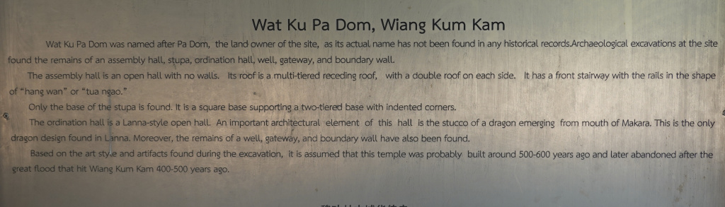
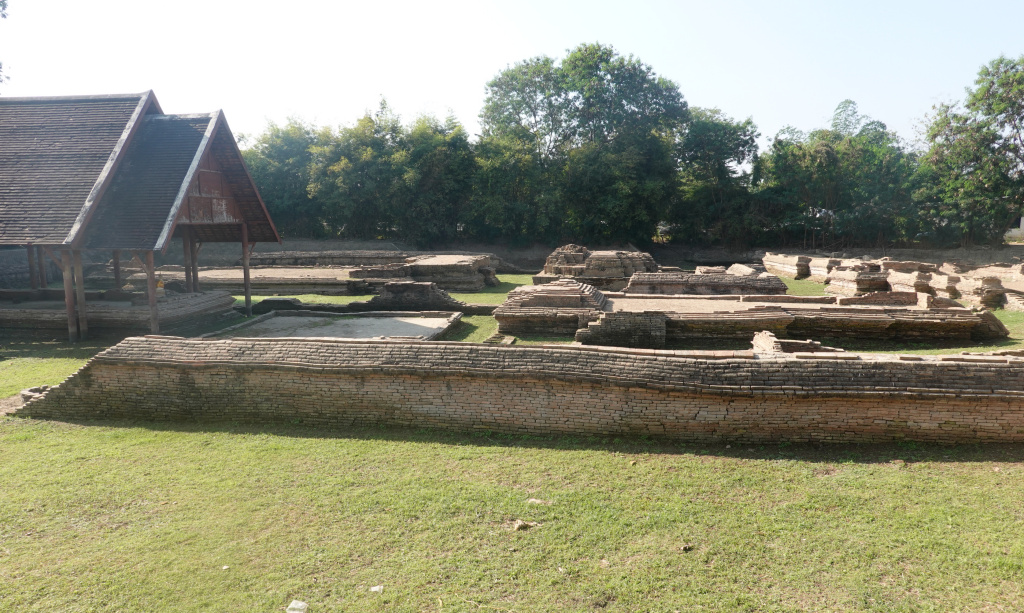
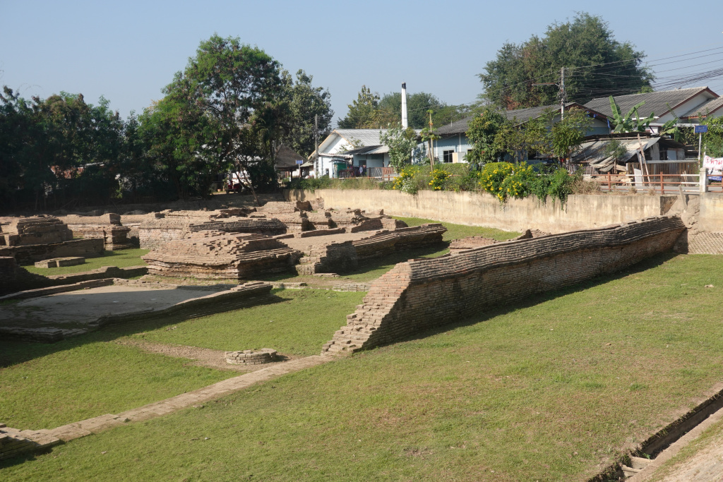
Wat Ku Pa Dom
The first site to which we went and the first site where the archeological excavations took place was Wat Ku Pa Dom, which stands on the grounds of an earlier temple named Wat Chang Kam. Here they discovered artifacts from both the early Lanna and Hariphunchai Periods, as well as the ruined foundations of the earlier temple. This discovery sparked the further exploration of the site and the excavation of 34 total monuments associated with the city of Wiang Kum Kam between 1984 and 2002. These monuments were found on the east bank of the Ping River, the former west bank, and buried 1-2 meters below the modern ground level. Here are a few photos of the ruins at Wat Ku Pa Dom: